


Montgomery Voting District, Montgomery County, Missouri
About
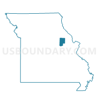
Outline

Summary
| Unique Area Identifier | 609169 |
| Name | Montgomery Voting District |
| County | Montgomery County |
| State | Missouri |
| Area (square miles) | 80.68 |
| Land Area (square miles) | 80.09 |
| Water Area (square miles) | 0.58 |
| % of Land Area | 99.27 |
| % of Water Area | 0.73 |
| Latitude of the Internal Point | 39.00021250 |
| Longtitude of the Internal Point | -91.50392200 |
Maps


Graphs
Select a template below for downloading or customizing gragh for Montgomery Voting District, Montgomery County, Missouri


Neighbors
Neighoring Voting District (by Name) Neighboring Voting District on the Map
- Bellflower Voting District, Montgomery County, MO
- High Hill Voting District, Montgomery County, MO
- Middletown Voting District, Montgomery County, MO
- Mineola Voting District, Montgomery County, MO
- New Florence/Danville Voting District, Montgomery County, MO
- Shamrock Voting District, Callaway County, MO
- Wellsville Voting District, Montgomery County, MO
Top 10 Neighboring County Subdivision (by Population) Neighboring County Subdivision on the Map
- Montgomery township, Montgomery County, MO (3,729)
- Bear Creek township, Montgomery County, MO (2,566)
- Danville township, Montgomery County, MO (1,950)
- Upper Loutre township, Montgomery County, MO (1,712)
- Prairie township, Montgomery County, MO (882)
- Shamrock township, Callaway County, MO (413)
Top 10 Neighboring Place (by Population) Neighboring Place on the Map
Top 10 Neighboring Unified School District (by Population) Neighboring Unified School District on the Map
- Montgomery County R-II School District, MO (8,610)
- Wellsville-Middletown R-I School District, MO (2,629)
Top 10 Neighboring State Legislative District Lower Chamber (by Population) Neighboring State Legislative District Lower Chamber on the Map
Top 10 Neighboring State Legislative District Upper Chamber (by Population) Neighboring State Legislative District Upper Chamber on the Map
Top 10 Neighboring 111th Congressional District (by Population) Neighboring 111th Congressional District on the Map
Top 10 Neighboring Census Tract (by Population) Neighboring Census Tract on the Map
- Census Tract 701, Callaway County, MO (5,108)
- Census Tract 9702, Montgomery County, MO (3,816)
- Census Tract 9703, Montgomery County, MO (3,268)
- Census Tract 9701, Montgomery County, MO (2,624)
- Census Tract 9704, Montgomery County, MO (2,528)